Trail Walking Brantôme en Périgord - boucle 2 - Photo
 morgoth
morgoth

User

© OpenStreetMap contributors
Length
Length
6 km
Max alt
Max alt
172 m
Uphill gradient
Uphill gradient
140 m
Km-Effort
Km-Effort  
7.9 km
Min alt
Min alt
100 m
Downhill gradient
Downhill gradient
140 m
Boucle
Boucle
Yes
Creation date :
2023-04-05 15:59:02.331
Updated on :
2023-04-05 16:00:30.613

(0 Reviews)

Walking
Walking
1h47
Difficulty : Medium

Scan this QR Code to open this trail in the SityTrail application

FREE GPS app for hiking

Logo SityTrail SityTrail

IGN / Geographical institutes

Download SityTrail from the App Store Download SityTrail from Google Play

Logo SityTrail SityTrail Plus

The world is yours!

Download SityTrail from the App Store Download SityTrail from Google Play Download SityTrail on Huawei AppGallery

About

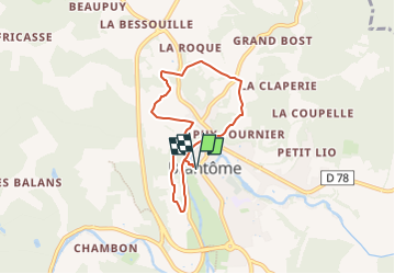
Trail Walking of 6 km to be discovered at New Aquitaine, Dordogne, Brantôme en Périgord. This trail is proposed by morgoth.

Description

Un des 4 circuits officiels proposés par la mairie de Brantôme-en-Périgord.
Vous pouvez trouver le PDF avec les points d'intérêt sur le site de la mairie ou de l'Office de Tourisme Périgord Dronne Belle (rubrique Téléchargements).

Elevation profile

Positioning

Country:
France
Region :
New Aquitaine
Department/Province :
Dordogne
Municipality :
Brantôme en Périgord
Location:
Unknown
Start:(UTM)
315808 ; 5025906 (31T) N.


Close
My subscriptions